GPS Phone Tracker Live Map
- 0.0
- Rating
- 10.00K
- Installs
- Free
- Price

 Analysis by App-foxy
Keeping track of people and places can become surprisingly awkward when everyone is moving, plans change, and messages arrive at different times. GPS Phone Tracker Live Map takes a focused approach to that problem: it is a free Maps & Navigation app from INDEGOFT built around staying connected with friends while exploring locations. I found its appeal less about replacing a full navigation suite and more about giving a group a simple way to think about where people are.
That distinction matters. A location tracker is useful when the question is “Where should we meet?” or “Has everyone reached the area?” It is not automatically the right tool for turn-by-turn driving, detailed route planning, or managing a large professional fleet. In my view, the app makes the most sense for small, informal groups that want a straightforward location-focused experience rather than a crowded platform with many unrelated functions.
Why the live map is the central idea
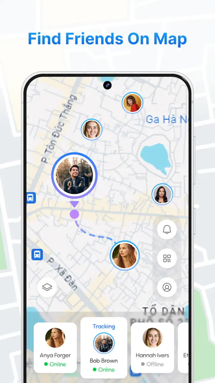
The strongest part of GPS Phone Tracker Live Map is the way it puts location at the center of the experience. Instead of treating maps as a background for dozens of features, the app is presented as a direct way to connect friends and explore places. That narrow purpose can be a real advantage for someone who does not want to learn a complicated system before using it.
You May Also Like

 Blood Strike: 2.5 Anniversary
Blood Strike’s Loadouts Turn Every Drop Into a Tactical Gamble
A close look at Blood Strike’s custom loadouts: how fast access to signature weapons reshapes its battle royale rhythm, rewards preparation, and narrows the gap between fights.

 Pandora - Music & Podcasts
Pandora’s Music Is Easy to Start, but Harder to Recover
Pandora’s strength is its low-effort path from a seed to a station. Its weak spot is how much confidence it asks you to place in connection, setup, and quiet recovery.

 8 Ball Pool
 Is Built on Rivalries, Rematches, and Routine
A close look at the rivalries, rematches, shared routines, and unanswered safety questions that turn a quick pool match into a persistent mobile community.

 Samsung Music
’s Quiet Strength Is Playing What You Already Own
Its reach comes less from spectacle than from dependable access to a personal library. That simplicity is both the app’s strongest retention engine and its ceiling.

 AccuWeather: Weather Radar
AccuWeather Review: A Quick, Clear Forecast for Everyday Decisions
For everyday plans, the best forecast is the one you can understand quickly. AccuWeather makes rain timing, radar, and local conditions easy to act on, with a few trade-offs.

 Hill Climb Racing
Why Hill Climb Racing Still Turns Crashes Into One More Run
A tiny car, a bumpy hill and one more upgrade: Hill Climb Racing keeps resurfacing because its simple chaos makes every near-miss feel personal.
More From Our News Desk
View All News


I would describe the main capability as shared location awareness. The practical benefit is not simply seeing a point on a map. It is reducing the need for repeated status messages when a group is trying to coordinate. If friends are approaching the same meeting area, a map-based view can make the situation easier to understand than a sequence of texts such as “I’m nearby” or “I’m five minutes away.”
That visual context is especially helpful in unfamiliar places. A written address may identify a destination, but it does not always show how spread out a group is, whether people are approaching from different directions, or which part of a broad area is most convenient. A location tracker can make those relationships clearer at a glance, provided everyone involved is comfortable using it.
There is also a useful difference between tracking a place and tracking a person. A map application normally helps me reach a destination. This app is more concerned with the relationship between people and locations. That makes it a companion to ordinary navigation rather than a complete replacement for it. I would still use a dedicated navigation service when I need route instructions, traffic context, transit details, or a carefully planned journey.
What that changes during everyday coordination
Imagine meeting friends at a busy outdoor area. One person arrives early, another is walking from a nearby street, and a third is looking for the correct entrance. In that situation, the useful question is not only where the destination is. It is where each person is in relation to it. A live map can turn that vague coordination problem into something more concrete.
I also see value for casual exploration. When a group is visiting an unfamiliar neighborhood, people often split up briefly to look at different places and then need to reconnect. A shared location view can support that freedom without making everyone send constant updates. The trade-off is that the group must agree on using the tracker and understand what information is being shared.
That consent element is not a minor detail. Location information is personal, even in a friendly setting. I would only use the app with people who clearly understand the arrangement, and I would avoid treating it as an invisible way to monitor someone. The best experience comes when tracking is temporary, purposeful, and mutually understood.
How I would use it in practice
Because GPS Phone Tracker Live Map is designed as a simple GPS phone tracker, I would begin with a small, clearly defined purpose instead of turning it into a permanent background habit. For example, before a day out, I would tell the group why we are using it, decide when location sharing is useful, and stop using it after the meeting or activity is finished.
A practical workflow is to establish the destination first, then use the live map for the part that ordinary map search does not solve: coordinating the people. This prevents a common mistake in location apps, where users expect the map alone to handle planning, directions, communication, and safety. The tracker is most useful when it has one job and the group knows what that job is.
For a meeting, I would choose a recognizable location rather than relying on a vague area. Broad locations can create confusion because a map may show that everyone is close while they are actually on opposite sides of a park, shopping complex, or event space. A more precise meeting point makes the live view more actionable. This is one of the simplest ways to get more value from a location-focused tool without needing advanced settings.
Another useful habit is to check the map before sending another message, but not to assume that a visual position answers every question. Someone may be inside a building, on a different level, or approaching from an inconvenient entrance. The live map helps with orientation; it does not remove the need for ordinary communication when the final few steps are unclear.
I would also avoid using the tracker as the only plan for a safety-sensitive outing. A map view can support coordination, but it should not replace telling a trusted person where you are going, carrying a charged phone, or agreeing on a backup meeting point. That is not a criticism of this particular app; it is an important limitation of location sharing in general.
A realistic day-to-day example
Consider a group of friends meeting in a large public area after arriving separately. One friend is already nearby, another is walking from public transport, and I am delayed by a change of plans. Instead of asking everyone to describe their exact position, I can use the tracker to understand the group’s general arrangement and suggest a meeting point that works for the people already closest together.
Once the group is reunited, I would stop treating the map as the main source of information. That is an important practical boundary. The app helps during the coordination phase, but keeping location sharing active after it is no longer needed adds exposure without adding much value. In my experience, the most sensible use of a tracker is often shorter and more intentional than people first expect.
The same approach works for a casual group walk. If people want to explore at different speeds, the map can make it easier to regroup without forcing the fastest person to wait at every corner. However, I would still agree on a time or place to reconnect. A live map is helpful for finding one another, but a simple plan prevents the group from depending on constant checking.
Where the app fits beside familiar alternatives
Most people already have access to a general map application. Those tools are usually better when the goal is finding businesses, calculating routes, checking travel options, or following spoken directions. GPS Phone Tracker Live Map is more specialized in emphasis: it is aimed at the social side of location awareness.
That specialization can make the app easier to understand for a user who only wants a location tracker. On the other hand, someone who wants one application to handle navigation, place discovery, traffic, messaging, and group planning may prefer an established all-purpose map service. Installing a focused tool is worthwhile only if its central purpose matches the way you actually travel.
It is also different from a messaging app with occasional location sharing. Messaging tools are excellent for conversation, but location information can become buried in a long chat. A dedicated tracker may feel clearer when the map itself is the main thing the group needs to consult. The trade-off is that it introduces another app into the group’s routine, and every participant must be willing to use it.
For professional tracking, I would look elsewhere unless the organization has specifically confirmed that this app meets its operational needs. Fleet management, employee dispatch, delivery coordination, and formal safety monitoring usually require specialized controls and workflows. A simple friend-oriented tracker is not automatically suitable for those responsibilities.
The friction that should shape your expectations
The biggest limitation is that location sharing is only useful when the people involved participate consistently. If one person does not open the app, does not want to share a position, or checks it irregularly, the group may still need to fall back on calls and messages. The app can reduce coordination friction, but it cannot remove the human part of planning.
Privacy is the second major trade-off. A live location can reveal routines, habits, and movements. I would not share it broadly, and I would be cautious about using it with acquaintances or in situations where the purpose is unclear. The strongest use case is a defined group, a clear activity, and a limited period of sharing.
There is also a difference between a live view and perfect real-world awareness. Buildings, crowded places, changing signal conditions, and simple user error can make a map less precise than expected. I would treat the displayed position as useful guidance, not as proof of someone’s exact physical spot. That mindset prevents unnecessary worry when the map and reality do not line up perfectly.
Another point is battery and attention. Any location-centered routine can encourage people to keep checking their phones, which may be distracting during travel or outdoor activities. I prefer using the tracker at natural checkpoints: before leaving, near the destination, and when regrouping. That gives the map a practical role without letting it dominate the outing.
The app’s current version is 1.0.0, so I would approach it as a focused and relatively early product rather than a mature platform with a long history of refinements. That does not make it unusable, but it does make realistic expectations important. I would test the experience with a small group before relying on it for a complicated trip, and I would keep a simple backup plan.
Who gets the most value from it
GPS Phone Tracker Live Map is a sensible choice for friends who regularly meet in unfamiliar places, families who want a simple way to coordinate during an outing, or small groups that separate and reunite during walks and visits. It may also suit someone who finds broader map applications overwhelming and wants the core idea of a GPS tracker presented more directly.
The app is available for free, which lowers the barrier to trying it with a group. It is rated for Everyone, and it runs on Android devices using OS 8.0 or later. Those details make it approachable for a wide range of everyday users, although the real test is still whether the people you need to coordinate with are happy to use the same tool.
INDEGOFT has kept the product identity clear: this is an app in the Maps & Navigation category, not a social network or a full travel planner. Its store presence shows over ten thousand installs, which suggests a modest footprint rather than the reach of a household-name mapping service. I would not choose it because of popularity; I would choose it because the focused location-tracking purpose fits a particular group routine.
I would skip it if my main need were detailed driving directions, public transport planning, business discovery, or professional vehicle monitoring. I would also skip it if the group is unlikely to agree on location sharing. In those cases, a normal map service or a communication tool already used by everyone may be more practical than introducing a separate tracker.
For the right audience, the app’s value comes from removing small moments of confusion. It can help answer where friends are in relation to one another, make regrouping easier, and give a shared visual reference when words are imprecise. Those benefits are modest but genuinely useful, especially in busy or unfamiliar places.
My final take on the live-map approach
After looking at the app through everyday use rather than its short store label, I see GPS Phone Tracker Live Map as a focused utility with a clear boundary. Its central capability is useful when several people need a common view of their locations, but it should not be mistaken for a complete navigation or safety system.
My recommendation is to use it deliberately, with consent and a specific meeting or exploration goal. Start with a small group, choose a clear destination, agree on when sharing is needed, and keep a backup way to communicate. Those habits address the main weaknesses of location tracking while preserving its strongest advantage: less guesswork when people are trying to find one another.
For a friend who wants a straightforward way to coordinate a day out, I would suggest giving it a try, especially since it is free and supports Android 8.0 or later. For someone searching for advanced routes, traffic information, or formal monitoring, I would point them toward a more specialized alternative. The app succeeds when it stays in its lane—and that lane is helping people connect through a simple view of where they are.
FAQs for GPS Phone Tracker Live Map
01What is GPS Phone Tracker Live Map and what does it do?
GPS Phone Tracker Live Map is designed to help users view and share real-time or recent location information through an interactive map. Depending on the version and enabled features, it may support location sharing with trusted contacts, route viewing, and device-position updates. Before using it, you should review the app’s feature list carefully, since availability can vary by device, operating system, subscription plan, and regional settings.
02Does GPS Phone Tracker Live Map require permission to access my location?
Yes. A tracking application needs location permission to determine and display a device’s position. During setup, the app may request access while it is being used or permission to operate in the background. Grant only the access you are comfortable with, and check your phone’s privacy settings regularly. Background tracking can also affect battery life, especially when location updates are frequent or continuous.
03Can I track another person without their knowledge or permission?
No. Location tracking should be used only with the clear knowledge and consent of the person being located. The app is more appropriate for voluntary family, friend, travel, or safety-related location sharing. Secretly monitoring someone may violate privacy laws, platform rules, or personal trust. Always explain how sharing works, who can see the location, and how the other person can stop sharing.
04Is GPS Phone Tracker Live Map free to download and use?
The application may be available to download at no initial cost, but some tools can require in-app purchases, a subscription, or advertising support. Premium features may include extended location history, more frequent updates, additional sharing options, or a reduced-ad experience. Check the current store listing before installing and review the billing terms carefully, particularly for automatically renewing subscriptions.
05How accurate is the location shown on the map?
The displayed position is not guaranteed to be perfectly precise. Accuracy depends on GPS signal strength, Wi-Fi and mobile-network coverage, device settings, battery-saving restrictions, weather or physical obstructions, and whether the phone is indoors. Updates may also be delayed when the app is running in the background. For safety-critical situations, treat the map as an aid rather than a replacement for emergency services or direct communication.
Pros
- Real-time location updates make it easy to monitor shared devices.
- Live map view provides a clear overview of tracked phones.
- Location sharing can help coordinate family members or friends.
- Useful for finding a misplaced phone when location access is enabled.
- Simple interface makes basic tracking features easy to access.
Cons
- Accurate tracking depends on GPS
- mobile data
- and battery level.
- Background location access may noticeably increase battery consumption.
- Privacy concerns arise when sharing location with other users.
- Indoor positioning can be inaccurate in buildings or crowded areas.
- Some advanced tracking features may require a subscription or ads.

GPS Phone Tracker Live Map
Gallery